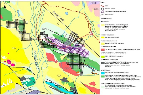
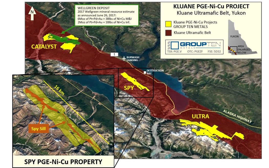
Kluane Project Overview
Stillwater Critical Minerals’ 260 square kilometre Kluane Project consists of the Spy, Ultra and Catalyst properties, all of which occur within the Kluane Mafic-Ultramafic Belt; a system of PGE-Ni-Cu deposits which are part of a sequence of mafic-ultramafic rocks that extends through the Yukon from northern British Columbia to central Alaska. The Kluane project properties are each within 15km of the Alaska Highway and situated on trend with, and south of, the Nickel Shaw (formerly Wellgreen) deposit, one of the largest undeveloped PGE-Ni-Cu projects in North America at 6 Moz of Pt+Pd+Au and 3 Blbs of Ni+Cu in M&I resources and an additional 2 Moz of Pt+Pd+Au and 1 Blbs of Ni+Cu in Inferred resources1.
Catalyst PGE-Nickel-Copper Property
The Catalyst property is located 35 kilometers (km) northwest of Burwash Landing and only 15km south of the Alaska Highway along the Donjek River. The project includes the Donjek-Arch claims, covering 6,770 contiguous hectares directly northwest of and adjacent to the Nickel Shaw deposit, and the North Corky and East Vault claims (CKR claims), consisting of 9,540 hectares directly southeast of and with portions adjacent to the Wellgreen deposit.
The Donjek claims were first staked on strongly anomalous aeromagnetic highs. In 2004, inversions of Geological Survey of Canada magnetic data determined that these anomalies are consistent with what would be expected from ultramafic rocks. Additional smaller magnetic highs are interpreted to be potentially a fault-bounded slice of ultramafic rock. A historic ground VLF-EM survey over the one of magnetic highs located an open-ended northwest trending conductor. Airborne geophysics completed in 1996 identified a well-defined resistivity low associated with a strong magnetic high and several moderately broad conductors. Geological mapping and sampling in 2001 identified pyritic mafic and ultramafic rocks, including peridotite and gabbro, underlying the claims. Five rock samples returned values as high as 424 ppm Cu; 4 ppb Pt, 247 ppm Cr, 681 ppm Ni and 18 ppb Au.
The Arch claims cover a nickel-copper-PGE showing, hosted by Triassic mafic to ultramafic sills of the Kluane Suite, intruding the Carboniferous Station Creek Formation. Also on the Arch claims is a showing with interstitial and disseminated pyrite, chalcopyrite±pentlandite in two 15m wide gabbroic bodies with an adjacent stockwork zones into older volcanic rocks that reported historic values of 0.20% Ni and 0.55% Cu with 0.15 g/t Au. A second showing one kilometer further to the south has disseminated pyrite, magnetite and pyrrhotite hosted in altered carbonate adjacent to a variably serpentinized peridotite sill, which returned 0.11 g/t Pt, 0.11 g/t Pd, 0.16% Ni, 0.07% Cu and 0.14 g/t Au over two meters. Additional historic magnetic and VLF anomalies are present on the property that require follow-up prospecting and sampling (from Yukon Geological Survey Minfile Nos. 115G-026, -033, and -088, Assessment Report Nos. 094396, 093662, 017513, 092578, 092575, 092744, 094253, 094250, 094466, 094217, 017459). Very little is known about the geology of the southeastern claims comprising the Catalyst Project. Mapping over portions of the claims indicates that sedimentary rocks similar to those found at Wellgreen are present, but ultramafic rocks have not been located.
Spy PGE-Nickel-Copper Property
The Spy property consists of 201 claims covering 40 square km, located approximately 7 km from the Alaska Highway and 40 kilometres southeast of the Company’s Catalyst property that adjoins the Nickel Shaw Ni-PGE project.
Clastic sedimentary rocks and limestone of the Hasen Creek Formation are exposed along the northeastern portion of the property, and are intruded by late Triassic and possibly older mafic to ultramafic sills including the Spy Sill.
The 75-100m thick Spy Sill intrudes Hasen Creek siltstone for a minimum of 6 km along a northwest strike, and dips to the southwest. The central portion of the sill consists of peridotite, with gabbro at the top and at the base. Mineralization varies from disseminations to massive sulphide lenses (up to 2.0 x 0.25m) with associated PGM in the basal marginal gabbro phase and its contact with the Hasen Creek siltstone.
PGE-Ni-Cu mineralization occurs within and along the base of the 75-100m thick ultramafic Spy Sill where it intrudes the Hasen Creek siltstone. Mineralization along the contact varies from disseminated to massive sulfide lenses, with historic grab samples from the massive sulphide lenses assayed as high as 3.1 g/t Pt, 1.4 g/t Pd, 1.0 g/t Au, 3.1% Ni and 2.8% Cu from the gabbro, and 75.8 g/t Pt, 7.9 g/t Pd, 7.0 g/t Au, 2.6% Ni and 10.45% Cu, from the footwall siltstone. (2)
Highlights of historic Spy property samples
| Showing | Length (m) | Pt+Pd+Au (g/t) | Cu % | Ni % |
|---|---|---|---|---|
| Spy | 1 | 9.1 | 0.45 | 0.16 |
| Spy | Grab | 90.7 | 10.5 | 2.6 |
| Bugs | 1 | 1.61 | 0.54 | 0.06 |
| Bugs | 1.6 | 1.68 | 0.76 | 0.06 |
| Bugs | 2.8 | 2.61 | 1.6 | 0.77 |
| Including | 0.9 | 5.54 | 3.66 | 1.44 |
| Wylie | 1 | 1.01 | 1.17 | 0.23 |
| Wylie | 1.7 | 1.26 | 0.97 | 0.3 |
| Taz | 0.3 | 2.51 | 0.39 | 0.1 |
| Sweet 16 | 1 | 4.47 | 0.12 | 0.04 |
| Spy South | grab | 2.5 | 0.38 | 0.20 |
Source: (3).
Ultra PGE-Nickel-Copper Property
The Ultra property covers 8,650 hectares and is located 42 kilometers (km) northwest of Haines Junction. At Ultra, a portion of the Frohberg PGM-Ni-Cu showing was trenched in 2002 and returned 5.54 g/t Pt, 13.46 g/t Pd, 4.07% Cu and 1.73% Ni over 0.5 meters. Numerous ultramafic occurrences elsewhere on the property are yet to be assessed for PGM-Ni-Cu potential.
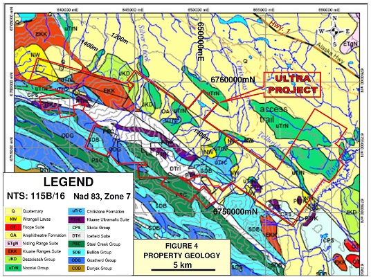
The Ultra property also includes the Telluride volcanogenic massive sulphide (VMS) showing, which is visible from the air and can be traced on the property for six kilometers along strike to the southeast. The showing itself contains values of 3.23% Cu, 6.75% Zn, 17.8 g/t Ag, and 0.15 g/t Au over four meters. (Channel widths were not reported in the historical sampling.) Since 1956, exploration on the Ultra Project has involved approximately 440 meters of drilling in eight holes on a VMS showing (1955-56, three core holes totaling 108m that failed to reach target depths; 1961-62, two churn drill holes totaling 116m that intersected minor native copper, and 1970, three core drill holes totaling 216m that intersected coal and marcasite). The ground has also been explored through hand trenching, rock, soil and silt geochemistry, a 1977 airborne electromagnetic survey, a 2004 airborne magnetics and electromagnetic survey, a ground magnetic and electromagnetic survey, and mapping (Pautler, J. 2012, Geological and geochemical assessment report on the Ultra Project, Whitehorse Mining District, Yukon, 47p.).
Sources:
(1) Based on 2017 Wellgreen Platinum mineral resource estimate as disclosed in a news release dated June 26, 2017 and available under the company’s profile on Sedar.com
(2) Bell, C. 1996. Report on 1995 geological and geochemical surveys on the Klu property. Yukon Dept. of Energy, Mines and Resources, Assessment Report #093371, 244p.
(3) Report on geological and geochemical surveys on the Klu property Yukon Dept. of Energy, Mines and Resources, Assessment Report #094164, Tulk 2000.
Debbie James, P.Geo., is the qualified person for the purposes of National Instrument 43-101, and she has reviewed and approved the technical disclosure contained in this section.